Andover was settled in 1636 under the Native American name of Cochichawicke, a local water-way. The community was incorporated in 1646 as the Town of Andover, named after a town in England where many of our settlers originated.
Andover’s economic base evolved from agriculture to industry during the 18th century. The region's first powder mill was established in 1775; the manufacture of paper began in 1789; and in the early nineteenth century, several textile mills prospered; notably the Smith & Dove Manfacturing Co., the first company in America to make linen shoe laces and sail thread.
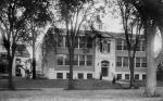
Education became an important local “industry” with the establishment of three academic institutions. Phillips Academy, founded in 1778, is one of the nation’s oldest preparatory schools. Abbott Academy, established in 1828 as one of New England’s first female academies, merged with Phillips Academy in 1973. The Andover Theological Seminary (1807), now part of Andover Newton Theological Seminary and the oldest graduate school of theology in the United States. The Andover Theological Seminary was responsible for the American missionary movement. The Andover Press founders Flagg & Gould published many of the Seminary works in several languages and is said to be the first to publish in Hebrew in America.
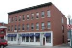
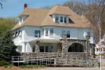
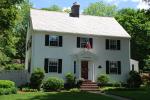
Andover’s built environment reflects its past with a rich diversity of styles spanning more than 350 years of architectural history. The town’s architecture defines its character and is among the community’s most treasured assets. Through this web site, the Andover Preservation Commission, the Andover Center for History & Culture, and the Memorial Hall Library hope to promote appreciation for our town’s heritage as it is expressed in its wonderful buildings.